Log in
All resources
Create a design
9,296 Free Artworks of Map Collection
bibliothèque nationale de france
national library of poland
atlas ou representation du monde universel t. 1 (1633)
maps by hendrik hondius the younger
copper engraving print
british library
joan blaeu
eran laor cartographic collection
1630s maps of the netherlands
atlas maior, vol 3 (germany) - joan blaeu, 1667 - bl 114.h(star).3
1593 maps of north america
cornelis de jode
old maps of amsterdam
evert maaskamp
map collection of leibniz-institut für länderkunde
maps of liège by baptista van doetecum
map collection of leibniz-institut für länderkunde
maps of liège by baptista van doetecum
map collection of leibniz-institut für länderkunde
maps of liège by baptista van doetecum
merian sueviae picture
baroque
august kneisel
atlases
vrbivm praecipvarvm totivs mvndi liber tertivs (1616)
maps of setenil de las bodegas by braun & hogenberg
17th-century maps of amsterdam
1620s maps of the netherlands
magni ducatus lithuaniae
maps facing west
maps of venice by braun & hogenberg
giacomo franco
maps by willem and johannes blaeu
william camden
theatri praecipvarvm totivs mvndi vrbivm : liber sextvs (1618)
maps of łowicz by braun & hogenberg
geographia universalis (1545) in the british museum
german renaissance,northern renaissance
de praecipvis totivs vniversi vrbibvs, liber secvndvs (1575)
maps of orléans by joris hoefnagel
maps of ancient israel by philippe de la rué
old maps of the tribes of israel
17th-century maps of the strait of magellan
1640 maps of south america
johannes nessel
batavia castle
picturesque palestine, sinai, and egypt (nypl scan)
orientalism
construction drawings in the stadsarchief amsterdam
daniel stoopendaal
prints in the stadsarchief amsterdam
jan roodenpoortstoren
birckenstein handgriffe (image set)
old maps of komárom
high renaissance
pirro ligorio
18th-century maps of istanbul
maps from gallica
stony brook, new jersey
battle of princeton
pierre antoine tardieu
françois houiste
maps of lake geneva by jacques goulart
eran laor cartographic collection
maps of lake geneva by jacques goulart
eran laor cartographic collection
eran laor cartographic collection
claes jansz. visscher (ii)
eran laor cartographic collection
claes jansz. visscher (ii)
1700s maps of rhineland-palatinate
maps of vangiones by sanson
maps of chester by braun & hogenberg
maps in the british museum
17th-century maps of vienna
maps by nicolaes visscher i
1660s maps of rhineland-palatinate
maps of vangiones by sanson
map of the circle of upper saxony by sanson
bibliothèque nationale de france
maps of jerez by braun & hogenberg
maps of conil by braun & hogenberg
maps of the islands of greece by marco boschini (1658)
old maps of karpathos
le royaume de france distingué by guillaume sanson
1724 maps of france
birds-eye view of seattle, 1884
seattle
bibliothèque nationale de france
maps of spain by tomas lopez
maps of spain by tomas lopez
18th-century maps of madrid
sanson maps of the circles of germany
1670s maps of baden-württemberg
nouvelle géographie universelle
1887 maps of africa
le royaume de france distingué by guillaume sanson
1724 maps of france
gottfried christian pingeling
1745 maps of hamburg
old maps of gâtinais and sénonais
maps by willem and johannes blaeu
maps of île-de-france by françois de la guillotière
atlas minor gerardi mercatoris (1614, maps)
maps of emden by braun & hogenberg
bibliothèque nationale de france
maps from gallica
guides joanne
1667 map of madagascar by guillaume sanson
bibliothèque nationale de france
sketchbook of northwest american and canadian scenery
hudson river school
maps of the islands of greece by marco boschini (1658)
old maps of astypalaia
map of the circle of franconia by sanson
1680s maps of bavaria
le royaume de france distingué by guillaume sanson
1724 maps of france
antonio carnicero
rococo
1720s maps of palestine
nicolas de fer
sanson maps of the netherlands
1670s maps of belgium
maps of the byzantine levant
1650s maps showing history
drawings in the groeningemuseum
jan de hervy
17th-century maps of the mediterranean sea
1610 maps of europe
images of venice by jacopo de' barbari
woodcuts in the rijksmuseum amsterdam
maps of antwerp by braun & hogenberg
maps of antwerp city walls
maps of antwerp by braun & hogenberg
maps of antwerp city walls
atlas ou representation du monde universel t. 1 (1633)
old maps of beauvais
atlas ou representation du monde universel t. 1 (1633)
maps by hendrik hondius the younger
atlas ou representation du monde universel t. 1 (1633)
maps of france by hendrik hondius
atlas ou representation du monde universel t. 1 (1633)
1630s maps of the netherlands
atlas ou representation du monde universel t. 1 (1633)
1630s maps of the netherlands
atlas ou representation du monde universel t. 1 (1633)
maps by hendrik hondius the younger
atlas ou representation du monde universel t. 1 (1633)
1630s maps of portugal
atlas ou representation du monde universel t. 1 (1633)
1630s maps of the netherlands
atlas ou representation du monde universel t. 1 (1633)
1630s maps of the netherlands
atlas ou representation du monde universel t. 1 (1633)
17th-century maps of scandinavia
atlas ou representation du monde universel t. 1 (1633)
1630s maps of the netherlands
atlas ou representation du monde universel t. 1 (1633)
old maps of languedoc
cartouche (cartography)
jean-claude dezauche
atlas ou representation du monde universel t. 1 (1633)
1630s maps of belgium
bibliothèque nationale de france
maps by thomas kitchin
bibliothèque nationale de france
maps by thomas kitchin
bibliothèque nationale de france
maps by thomas kitchin
john rocque's 1748 map of london and adjacent country
remigius parr
collection cartographic documents from het utrechts archief
albertus barend hendrik braakensiek
collection cartographic documents from het utrechts archief
albertus barend hendrik braakensiek
1670s maps of the iberian peninsula
georg widmann
pierre alexander tardieu
delaval (surname)
old maps of katwijk, south holland
brittenburg
anthonisz., cornelis - gezicht op amsterdam in vogelvlucht - amsterdam museum
oil on panel
a description of the new york central park (1869)
maps from the mechanical curator collection
historical images of palais des princes-evêques de liège
maps by willem and johannes blaeu
the custom house, dublin (1707)
essex bridge
maps of barbary coast by mercator-hondius
eran laor cartographic collection
maps by emanuel bowen
1744 fleurons
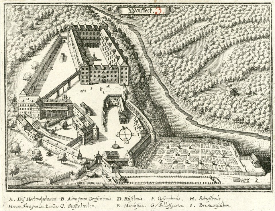
atlas maior, vol 3 (germany) - joan blaeu, 1667 - bl 114.h(star).3
copper engraving print
atlas maior, vol 3 (germany) - joan blaeu, 1667 - bl 114.h(star).3
copper engraving print
atlas maior, vol 3 (germany) - joan blaeu, 1667 - bl 114.h(star).3
copper engraving print
atlas maior, vol 3 (germany) - joan blaeu, 1667 - bl 114.h(star).3
copper engraving print
atlas maior, vol 2 (sweden, russia, poland, eastern europe, and greece) - joan blaeu, 1667 - bl 114.h(star).2
copper engraving print
atlas maior, vol 2 (sweden, russia, poland, eastern europe, and greece) - joan blaeu, 1667 - bl 114.h(star).2
copper engraving print
atlas maior, vol 1 (northern europe, norway, and denmark) - joan blaeu, 1667 - bl 114.h(star).1
copper engraving print
atlas maior, vol 3 (germany) - joan blaeu, 1667 - bl 114.h(star).3
copper engraving print
5301 - 5400 of 9,296
Next page
/ 93